ACRA is celebrating the work of its member firms through this new series highlighting 2022 projects. To be featured, submit your project here.
Integration of Shallow Geophysics, Archaeology, and Photographs at Ingleside Plantation
Lincoln Co., NC
Seramur & Associates, PC
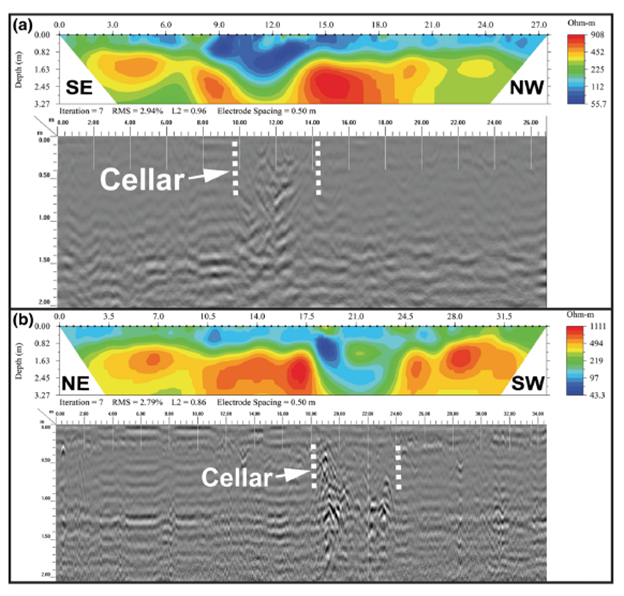
Featured image above: Electrical resistivity tomography transects 4 and 5 paired with GPR profiles. This data images the cellar of the double-pen cabin where the Forney’s were held captive by Cornwallis during his Southern Campaign of the revolutionary war.
Ground penetrating radar supported by electrical resistivity tomography and gradiometer surveys were used to map buildings and infrastructure documenting sequential property use by three generations of the Jacob Forney family who began as farmers in the backcountry of North Carolina and rose to prominence in government and industry within the Southeastern United States. At Ingleside, the antebellum plantation house has been preserved and the adjacent property remains relatively undisturbed.
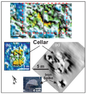
GPR depth slice from 0.7 to 0.8 m showing outline of debris in cellar. B. Depth slice from 0.2 to 0.3 m showing likely outline of Structure 3. C. Hill shade map of gradiometer data in G-13 showing magnetic anomalies that coincide with the high amplitude GPR reflections in the cellar. An iron spike buried approximately 10 cm (shown in inset) beneath the surface is recorded by a point source magnetic anomaly.
Context for the geophysical surveys was provided by archival photographs, written accounts including monographs and newspaper articles, and an archaeological excavation of the fallen stone chimney and hearth within the plantation’s summer kitchen. The location of an early log home with its stone-lined cellar with ties to the Piedmont Campaign of the American Revolution (in 1781) was newly discovered. In addition, a historic road, kitchen garden, and the postholes from an early post-in-the-ground building were imaged within the subsurface. The external summer kitchen and privy are associated with the plantation house constructed in 1817. Modernization and occupation of the brick mansion to the present day has resulted in disruption of the subsurface by the installation of a septic tank and underground utilities. Several cesspool vaults of potential privies are ingrown with trees.
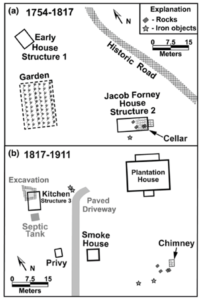
Plan view of the grounds of the original farmstead (A) and the Antebellum planation (B) as identified in this study.
The results of the geophysical surveys document the evolving land use within one family during a critical period of change in the American South and can be connected to specific events in history, a goal of historical archaeology.